Salmon Arm, BC - Part 3
Part 3 - Hiking the Upper Canyon Trail
After completing the Margret Falls hike, I still felt up to another hike, so we took a longer, steeper trail within Herald Provincial Park. Here's a map for those interested:
According to Hike Kamloops (LINK), this trail is a little more strenuous, is dog friendly and is about 4.1 kilometers long. It took us about an hour to complete the loop, starting from the lake overflow parking lot on the right side of the road.
Here's a quick view of the beach front facing the lake. It's a beautiful spot with lots of picnic tables under large, shady trees:
The trail is very steep for the first kilometre or so with a number of switchbacks up the hill. According to my Garmin, the elevation gain was 178 meters. At the start, the trail is narrow and snakes through the forest, as you can see below:
Once you reach the top of the hill, you'll come across this scenic lookout. You can see the lake overflow parking area at the bottom of the photo:
Deep into the forest, you'll come across a trail marker directing you towards different routes. We went straight.
Map shows the entire loop.
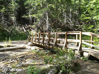
At the top of the loop, we found this wooden bridge which traverses the river. I dipped my hands in the water too because it looked so beautiful. I was surprised; it was not as cold as expected.
The loop back was very easy; for those who are not experienced hikers, I would recommend only hiking this part of the trail. It's wide, the underbrush is soft with few rocks and has a gradual slope.
Once we made it back, we entered through the gate to walk the trails that snaked their way through the park campground. That was really fun to be honest! We crossed some small rivers by just stepped over stone or logs placed in strategic places.
The gate and trail markers showing you can cut through the campground to the parking area.
At larger crossings, the park staff had installed silver metal bridges, making those crossings much easier.
We completed our hike by eating lunch at a picnic table by the beach at the lake (see the first picture featured in this post). This park is really great! It's free for the day, there is a "dog beach" for pooches to play in the water, and has lots of picnic tables and hiking trails to enjoy the fine weather. Highly recommended!
Next post: Salmon Arm, BC - Part 4 Cycling the Shuswap Hills
References:
Bunny Luv [screen name]. (2020). Columbia-Shuswap upper canyon trail [map]. Garmin Connect. Used by permission.
Hike Kamloops. (2020). Margret falls upper canyon loop trail. URL.
All photos by Cutenekko taken on a Huawei P10 Lite.


Comments
Post a Comment